GDAL: Unlocking the Power of Geospatial Data
Imagine trying to read a map, but the map comes in dozens of formats — TIFFs, GeoJSON, Shapefiles, NetCDF, and more. You need a translator, someone who can understand each format and help you extract meaningful insights. That translator is GDAL, or the Geospatial Data Abstraction Library — the silent workhorse powering geospatial analytics across industries.
Whether it’s tracking climate change, analyzing urban growth, or powering GPS applications, GDAL ensures that geospatial data is accessible, usable, and interoperable. In this article, we’ll explore GDAL in depth: what it is, how it works, its use cases, pros and cons, alternatives, industry trends, and real-world projects — all told in a storytelling, blog-friendly tone.
What Is GDAL?
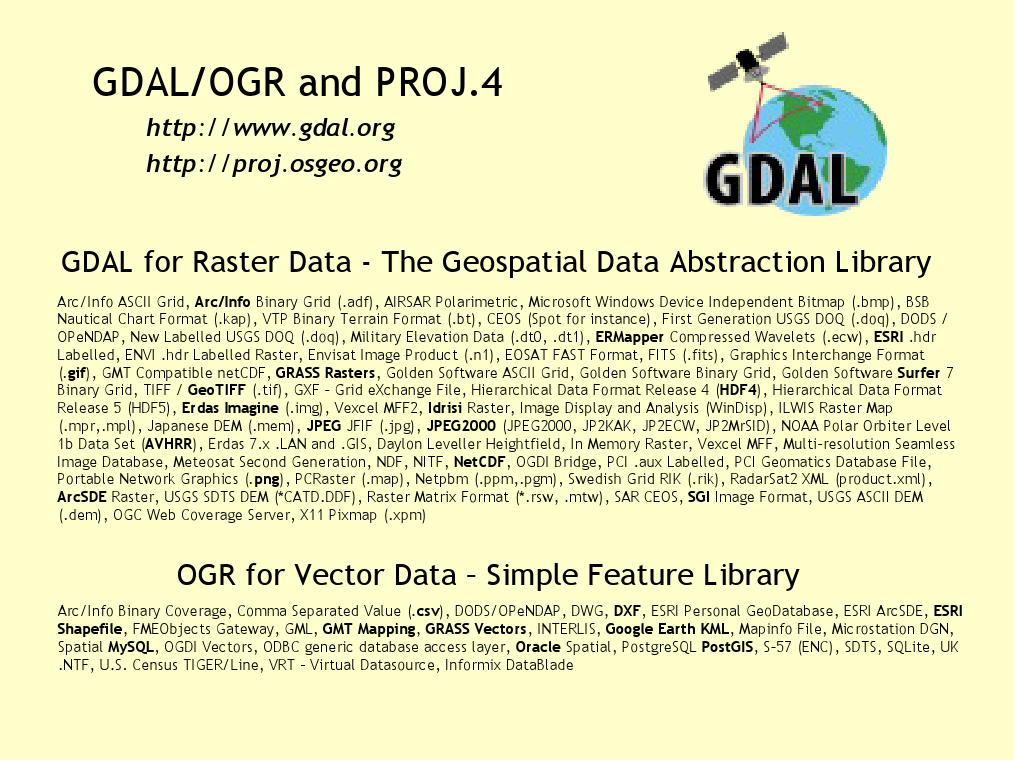
Image Courtesy: live.osgeo.org
GDAL (Geospatial Data Abstraction Library) is an open-source translator library for raster and vector geospatial data formats. It provides a unified API to read, write, and transform geospatial data across hundreds of file formats.
Think of GDAL as a universal adapter for spatial data — no matter the source, GDAL can read it, manipulate it, and even convert it into a different format for your analysis.
GDAL also comes bundled with OGR, which specifically handles vector data. Together, GDAL + OGR allow seamless handling of raster and vector data, making it a cornerstone of GIS (Geographic Information Systems) and remote sensing workflows.
A Brief History
GDAL was first released in 2000 by Frank Warmerdam. Its goal was simple but ambitious: provide a single library to handle all geospatial formats. Over the years, it has become the backbone of many open-source GIS projects such as QGIS, MapServer, PostGIS, and Python’s Rasterio.
Why GDAL Matters ?
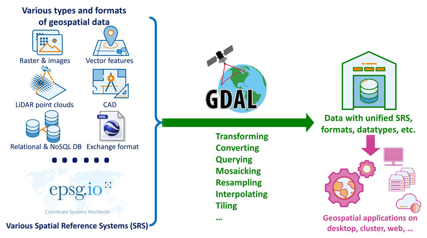
Image Courtesy: Researchgate
- Interoperability: Handles over 200 raster and 100 vector formats.
- Efficiency: Optimized for large datasets and geospatial transformations.
- Community Support: Active open-source community ensures regular updates and bug fixes.
- Integration: Works seamlessly with Python, C++, Java, and other languages, allowing developers to build complex GIS pipelines.
How GDAL Works
Understanding GDAL is easier when broken into core components and workflows:
- Raster Data Handling
Raster data represents information as grids of pixels, such as satellite imagery, DEM (Digital Elevation Models), or aerial photos.
- Reading Raster Data: GDAL can read formats like GeoTIFF, HDF, NetCDF, JPEG2000, and more.
- Transformations: It supports coordinate system transformations, resampling, cropping, and merging of raster layers.
- Raster Operations: Analysts can compute NDVI, slope, aspect, or perform other raster-based calculations directly via GDAL.
- Vector Data Handling (via OGR)
Vector data represents points, lines, and polygons — like city locations, roads, or country boundaries.
- GDAL/OGR supports formats such as Shapefile, GeoJSON, KML, PostGIS, MapInfo, and many others.
- Operations: GDAL allows reprojection, simplification, geometry validation, and attribute manipulation.
- This makes it essential for GIS analysis, spatial querying, and map generation.
- Coordinate Systems and Projections
GDAL has robust support for CRS (Coordinate Reference Systems):
- Reproject datasets to a common CRS for analysis.
- Transform between geographic coordinates (lat/long) and projected coordinates (UTM, Mercator, etc.).
- Ensure spatial alignment across multiple datasets.
- Command-Line Utilities
GDAL is not just a library — it comes with powerful command-line tools:
- gdalinfo – Provides metadata about raster datasets.
- gdal_translate – Converts raster formats.
- gdalwarp – Reprojects and warps raster datasets.
- ogr2ogr – Converts and manipulates vector data.
These tools make GDAL a versatile choice for data preprocessing, batch processing, and automation in geospatial projects.
Use Cases / Problem Statements Solved with GDAL
GDAL is versatile and can solve a wide range of geospatial challenges:
- Remote Sensing and Satellite Imagery
- Problem: Satellites produce images in different formats with varying projections.
- GDAL Solution: Harmonizes data, applies reprojection, mosaics images, and computes derived products like NDVI or land cover classification.
- Urban Planning and Infrastructure
- Problem: City planners need accurate GIS data from multiple sources to plan roads, utilities, and zoning.
- GDAL Solution: Converts and merges datasets (vector and raster), ensuring uniform projections for analysis and visualization.
- Environmental Monitoring
- Problem: Monitoring deforestation, flooding, or climate change requires consistent spatial datasets over time.
- GDAL Solution: Automates data ingestion, alignment, and extraction, enabling time-series analysis and environmental modeling.
- Geospatial Analytics in Finance
- Problem: Financial institutions require spatial data for risk modeling (e.g., flood zones, insurance claims).
- GDAL Solution: Integrates diverse geospatial datasets, allowing analysts to perform spatial queries and generate risk models.
- Navigation and Transportation
- Problem: GPS and navigation systems rely on spatial data from multiple sources.
- GDAL Solution: Converts map data to standardized formats for route optimization, traffic analysis, and geofencing.
- Big Data and GIS Integration
- Problem: Handling large geospatial datasets from IoT sensors, drones, or satellites.
- GDAL Solution: Optimized for large files, supports streaming, and integrates with PostGIS, HDFS, and cloud storage.
Pros of GDAL
- Wide Format Support: Handles 200+ raster and 100+ vector formats.
- Open Source and Free: No licensing cost, actively maintained by the community.
- Cross-Platform: Works on Windows, Linux, Mac, and integrates with multiple languages.
- Automation Friendly: Command-line tools enable batch processing.
- Robust Projection Support: Supports CRS transformations for consistent spatial analysis.
- Extensible: Can be integrated with Python, C++, Java, R, and GIS software like QGIS.
Limitations of GDAL
- Steep Learning Curve: Complex for beginners unfamiliar with geospatial concepts.
- Limited GUI: Primarily a library and command-line tool; requires other software for visualization.
- Memory Intensive: Very large raster datasets can require significant RAM.
- Sparse Documentation for Advanced Features: While core functions are well-documented, some niche features need community support.
Alternatives to GDAL
While GDAL is widely used, some alternatives exist depending on requirements:
- Rasterio / Fiona (Python Wrappers): Simplified GDAL access with Pythonic APIs.
- PostGIS: Database-driven spatial operations.
- ArcGIS / QGIS: Desktop GIS platforms with GUI support and built-in tools.
- GeoTools (Java): Open-source geospatial library for Java developers.
- Google Earth Engine: Cloud-based geospatial analytics for remote sensing applications.
Upcoming Updates / Industry Insights of GDAL
- Cloud Integration: GDAL now supports S3, Google Cloud Storage, and Azure Blob Storage for large-scale geospatial processing.
- Python Ecosystem Growth: Packages like Rasterio, Fiona, and Geopandas leverage GDAL, making Python the de facto language for GIS scripting.
- High-Performance Computing: GDAL is being optimized for GPU acceleration and parallel processing.
- AI & Remote Sensing: GDAL is crucial for preprocessing datasets used in deep learning for satellite imagery analysis.
Project References of GDAL
Frequently Asked Questions of GDAL
Q1. What is the difference between GDAL and OGR?
- GDAL handles raster data, OGR handles vector data, but they are bundled together in the GDAL library.
Q2. Can I use GDAL with Python?
- Yes! Python bindings allow you to use GDAL, Rasterio, and Fiona to manipulate geospatial datasets programmatically.
Q3. Does GDAL support cloud storage?
- Yes, it supports S3, Google Cloud Storage, Azure, and HDFS for large-scale data workflows.
Q4. Can GDAL handle projections automatically?
- GDAL allows reprojection, transformation, and alignment of datasets to any supported CRS.
Q5. Is GDAL suitable for beginners?
- It’s powerful but has a steep learning curve; using Python wrappers or QGIS GUI can make it more beginner-friendly.
Third Eye Data’s Take on GDAL
At Third Eye Data, GDAL serves as a foundational layer in our geospatial stack. We use it for coordinate transformations, raster warping, reprojection, and format conversions. It underpins our ability to ingest multi-source imagery reliably and feed clean, aligned raster data into our AI models and analysis pipelines.
GDAL is more than a library — it’s the glue that holds geospatial data workflows together. By abstracting the complexity of hundreds of file formats and projections, it empowers analysts, developers, and organizations to derive actionable insights from spatial data.
From environmental monitoring to urban planning, autonomous vehicles, and big data analytics, GDAL continues to be an indispensable tool in the geospatial ecosystem.
Call to Action
Ready to unlock the power of GDAL?
- Install GDAL via Python or OS package managers.
- Explore gdalinfo, gdal_translate, gdalwarp, and ogr2ogr.
- Start experimenting with satellite imagery, shapefiles, and geospatial projections.
- Integrate GDAL with Python, PostGIS, or QGIS to build advanced geospatial analytics pipelines.
Dive into GDAL, and let your geospatial data tell its story!