ThirdEye Data Logo - For Official Use

AI-based Vegetation Indices Solution

The AI-based Vegetation Indices Solution leverages satellite imagery and machine learning to monitor crop health, detect stress, and generate actionable insights for precision farming. By analyzing multispectral bands (RGB, NIR, SWIR), it computes NDVI, EVI, NDWI, and other indices to provide farmers, agronomists, and agribusinesses with real-time visibility across large farmlands.

This solution enables data-driven decisions on irrigation, fertilization, and harvesting – improving yields, conserving resources, and supporting sustainable farming.

AI-based vegetation indices solution — An advanced system that uses AI and remote-sensing data to automatically calculate vegetation health metrics (like NDVI, EVI, SAVI). It enables accurate crop monitoring, early stress detection, yield insights, and large-scale land assessment for agriculture and environmental management.

Business Challenges or Pain Points Addressed

  • Manual field inspections are slow, labor-intensive, and unscalable.

  • Early crop stress is often missed, leading to 15–25% yield losses.

  • Inefficient water, fertilizer, and pesticide usage increases costs and harms the environment.

  • Fragmented datasets (soil, crop, weather) prevent holistic insights.

  • Lack of predictive analytics limits ability to anticipate disease or yield gaps.

Our Solution Approach

The system processes satellite images, extracts spectral bands, computes vegetation indices, and produces:

  • Crop health maps with NDVI, EVI, NDWI

  • Zoning maps highlighting healthy vs. stressed regions

  • Recommendations for irrigation, fertilization, and early disease prevention

The result: scalable, objective, and automated insights for smarter crop management.

Technologies Used

  • Remote Sensing & Geospatial AI: Rasterio, GDAL, OpenCV

  • Machine Learning Models: Random Forest, SVM, K-Means, Regression, U-Net for segmentation

  • Data Sources: Sentinel-2, Landsat-8, MODIS, ISRIC SoilGrids, NASA POWER

  • Deployment: Streamlit UI, Docker containers, APIs for ERP/Farm Management integration

Core Features of This Solution

AI-based vegetation indices solution — An advanced system that uses AI and remote-sensing data to automatically calculate vegetation health metrics (like NDVI, EVI, SAVI). It enables accurate crop monitoring, early stress detection, yield insights, and large-scale land assessment for agriculture and environmental management.

Multi-band Image Analysis

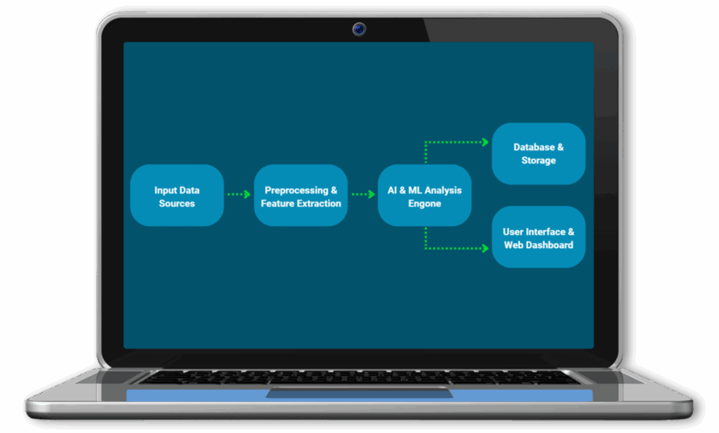
Supports RGB, NIR, and SWIR inputs to deliver a multi-dimensional view of crop health across large farmlands.

AI-based vegetation indices solution — An advanced system that uses AI and remote-sensing data to automatically calculate vegetation health metrics (like NDVI, EVI, SAVI). It enables accurate crop monitoring, early stress detection, yield insights, and large-scale land assessment for agriculture and environmental management.

Vegetation Indices Computation

Generates NDVI, EVI, NDWI, and SAVI to detect stress, water deficits, or healthy growth patterns in crops.

AI-based vegetation indices solution — An advanced system that uses AI and remote-sensing data to automatically calculate vegetation health metrics (like NDVI, EVI, SAVI). It enables accurate crop monitoring, early stress detection, yield insights, and large-scale land assessment for agriculture and environmental management.

Real-time Crop Health Reports

Instant reports provide farmers with detailed health maps, reducing manual inspections by up to 80%.

AI-based vegetation indices solution — An advanced system that uses AI and remote-sensing data to automatically calculate vegetation health metrics (like NDVI, EVI, SAVI). It enables accurate crop monitoring, early stress detection, yield insights, and large-scale land assessment for agriculture and environmental management.

Zoning & Classification

Automatically segments fields into stressed vs. healthy zones for targeted intervention and resource efficiency.

AI-based vegetation indices solution — An advanced system that uses AI and remote-sensing data to automatically calculate vegetation health metrics (like NDVI, EVI, SAVI). It enables accurate crop monitoring, early stress detection, yield insights, and large-scale land assessment for agriculture and environmental management.

Actionable Recommendations

Suggests irrigation, fertilization, and disease prevention steps to reduce losses and optimize yields.

AI-based vegetation indices solution — An advanced system that uses AI and remote-sensing data to automatically calculate vegetation health metrics (like NDVI, EVI, SAVI). It enables accurate crop monitoring, early stress detection, yield insights, and large-scale land assessment for agriculture and environmental management.

Scalable to Large Areas

Easily processes thousands of hectares using cloud infrastructure, suitable for individual farms or cooperatives.

Tangible Business Value Across Functions

Illustration of a team collaboration concept with a central figure surrounded by gear and two supporting figures, representing automated document processing and content management solutions.

Operations Efficiency

Automates monitoring across wide farmland, reducing manual labor costs by up to 70%.

AI-based vegetation indices solution — An advanced system that uses AI and remote-sensing data to automatically calculate vegetation health metrics (like NDVI, EVI, SAVI). It enables accurate crop monitoring, early stress detection, yield insights, and large-scale land assessment for agriculture and environmental management.

Farm Management

Improves decision-making with real-time insights, leading to more precise input usage.

Green delivery truck representing logistics and supply chain automation in computer vision applications.

Supply Chain Planning

Predicts yields early, helping agribusinesses plan procurement and logistics more effectively.

Enterprise agentic AI-based customer loyalty assistant solution blending AI agents, behavior analytics, segmentation and real-time campaign recommendations

Financial Planning

Supports crop insurance and financing with accurate, data-backed assessments of crop conditions.

AI-based vegetation indices solution — An advanced system that uses AI and remote-sensing data to automatically calculate vegetation health metrics (like NDVI, EVI, SAVI). It enables accurate crop monitoring, early stress detection, yield insights, and large-scale land assessment for agriculture and environmental management.

Sustainability Goals

Promotes water and fertilizer conservation, reducing waste and supporting ESG initiatives.

AI-based vegetation indices solution — An advanced system that uses AI and remote-sensing data to automatically calculate vegetation health metrics (like NDVI, EVI, SAVI). It enables accurate crop monitoring, early stress detection, yield insights, and large-scale land assessment for agriculture and environmental management.

R&D & Agronomy Teams

Provides reliable vegetation data for research, trials, and large-scale agricultural innovations.

See It in Action

Explore how our AI-powered crop health analysis works in real scenarios.

Real-World Value Created Through This Automation

  • Reduced manual inspections by 70–80% in pilot deployments.

  • Prevented up to 20% yield loss by detecting early crop stress.

  • Optimized water and fertilizer usage, saving 15–25% in input costs.

  • Delivered reliable yield predictions with 85–90% accuracy.

What Makes This Solution Different

It does not work like generic remote sensing tools; this system combines advanced AI with multispectral imagery to provide actionable, real-time recommendations rather than raw data.

FAQs – Answering Common Business Asks

  • Can this work with drones as well as satellites?
    Yes, it supports both UAV/drone imagery and satellite data.

  • How accurate are the vegetation indices?
    NDVI/EVI scores achieve 85–90% reliability when calibrated with ground truth data.

  • Can the solution integrate with irrigation systems?
    Yes, APIs enable integration with irrigation controllers for automated action.

  • Does it require high technical expertise to use?
    No, the interface is intuitive and farmer-friendly.

  • How frequently can crop data be updated?
    As frequently as satellite passes occur (every 5–10 days with Sentinel-2).

Book a Demo to Interact and See It in Action

CONTACT US